We recently completed a project for Yealands Estate in Marlborough which posed a couple of interesting challlenges that we wanted to share with you. The app had to be available in 6 languages and the existing maps of the area were not that great.
Mapping
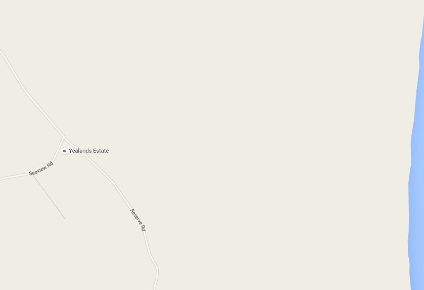
Many platforms use Google Maps for their mapping which is OK if you’ve got well mapped areas and you want a more ‘street map’ based look for your app. At My Tours we use maps based on Open Street Map which allows you to add you own data to the map. Consider this Google Map of the area:
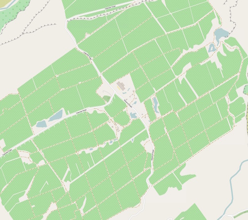
By editing the Open Street Map version of the map we were able to add a lot more data to the map. We could add everything from buildings to vineyards and picnic tables:
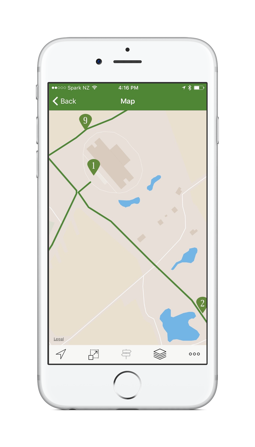
And the result in the app? The default rendering of the Open Street Map using Mapbox is looking pretty good:
There are a few more things we can do given time and budget. For example we could create a completely unique style to match any corporate branding or we could import any special layers and style these in a particular way to highlight certain features. Get in touch if you would like any custom map work done on your app.
Translations
The app also needed to be available in six languages and be released in under 3 weeks. We were supplied the content in English and used our translators to turn around the translations in under a week. The result? An app released on time, in six languages.
We recently published an app for Hobsonville Point Secondary School. It explores the school’s surrounding area, in particular the rich aircraft history of New Zealand’s first international airport. That’s not even the best part, though — the app was created by the school’s year 9 and 10 students. The other great thing is that the app’s proceeds go to charitable organisation KidsCan.
We had a chat to the innovative Sarah Wakeford from the school, and asked about the experience and thinking behind making the app.
What gave you the idea of making a tour app?
Glen from My Tours approached the school showing us the potential for student led learning using the app. We are always interested in authentic real world learning opportunities and I saw straight away that it could be a fantastic project for our students.
What was the thinking behind it?
My initial thoughts were really focussed on the area we live in and the important history that is found here. We are on an old airbase site, with lots of history around aircraft (this was NZ’s first international airport). As the community grows and develops, this history is being lost. I see it as our schools responsibilty to try and protect as much of the history as possible. My Tours App seemed like a fantastic tool to help us do this.
Why My Tours?
My Tours seemed very straightforward and manageable for students in Yr 9 and 10 to create. The software was easy for our kids to use, had lots of versatility and looked very professional – so our kids could do an amazing job. Glen was happy to help in all stages of the production, which put me at ease. He was always working with the kids and helping them to improve what they were doing.
It was an awesome idea to involve the students in creating the app — was organising all the different parts challenging?
Setting up the ‘accounts’ for Google and Apple was a little challenging at first – just finding the time to meet with the finance and IT expertise to set up all the accounts was a bit tricky. The actual creation of the trail was very smooth, and Kim Mi the project leader found putting the trail together very straightforward, once all the passwords and accounts were set up.
How did they find the tour content?
The students decided to keep the first project very small and managable – so they decided on 5 key sites in the Hobsonville Point area – knowing that it was better to research these sites well and do a good job, rather than spread themselves too thin. However, on reflection they could have done 10 sites, as they found the process really straightforward and there was definitely time to do more. The idea is to build on this site and increase the trail in 2016.
Did they enjoy it?
Absolutely – here are some quotes from the student reflections:
*I really liked learning about the history and then being able to do something about it. We could share the information with the community and also help raise money for KidsCan, so that felt really good. I also liked working as a team and seeing a final product at the end. The project was cool. – Kim Mi
*I really enjoyed the design stuff we did for the app – it was cool to make logos and find images and photos, choose colours and create the app – it felt like you were doing a real design project as well as a history project. – Matthew
What about production — who took all of the photos and recorded the audio?
The students collected the photos from the on-line archive sites and also took photos themselves at the different spots. Students also did all the recording themselves at our recording studio at school.
How long did it take?
Student worked on the history trail for approx 10 weeks – every Wed from 12.00 – 3.00pm. They also did promotional material, a website and other resources to promote the app and the history of Hobsonville Point.
Who had the idea to sell the app and donate the proceeds to KidsCan?
The project is part of a learning programme here at HPSS called “Big Projects” and the idea as all the projects have to contribute to a ‘big picture’ partnership or challenge, which for semester one in 2015 was raising money for KidsCan. Over 120 students were involved in enterprise projects that had to raise funds for kids living in poverty. It was a fantastic opportunity for our students to use the app to also do a positive thing for kids in need – so that was a great connection to the overall Big Project challenge.
In 2016 there will be a range of history projects and we hope to improve on the trail and add new ones 🙂
Header Image: Aeroplane assembly, Hobsonville RNZAF base, with plane in cratee. Whites Aviation Ltd :Photographs. Ref: WA-21516-G. Alexander Turnbull Library, Wellington, New Zealand. http://natlib.govt.nz/records/23011349
At the NDF 2015 conference I gave a talk on measuring the success of your open data work. Here is text and the YouTube video for the talk.
1. Intro
I said in my pitch for this talk that no GLAM organisation in New Zealand provides truly open data and this makes me a little sad. Now, I’m not going to go into why you should do open data, there is a great presentation called The Future is Open by Michael Edson which I recommend you take a look at if you need to be convinced.
The good news is that there are very few if any organizations worldwide who are doing it right. So, we’re not alone.
But what is right?
Well, firstly we should define data. And sometimes it is easier to define what data isn’t. Data is not metadata, data is not numbers, data is not charts, data is not image files, data is not essays.
Data is all of the things. Data is everything that your organization outputs. To steal a proverb, one man’s essay is another man’s corpus of text mining training data. And when you think about it an image is simply data on a point in time.
2. NZGOAL
So if we think about data like this, how do we make it open? Contrary to popular belief open data is not a CC license. Now NZGOAL, along with other tools are great initiatives and we hear a lot about these in the GLAM sector.
And when we dive into these one by one we can easily measure ourselves against the principals.
4. Open:
Data should be open. You need a really, really, really good reason not to release it. I’m not going to go into the OIA in 7 minutes but national security probably isn’t the reason why you are choosing to not open something, although the archivist for the GCSB may beg to differ. So what is your moral argument for not opening something?
5. Protected:
Of course, some items are going to be personal or confidential — so how do we deal with those? At what point does a soldier’s medical record become acceptable? For our sector I’d go further and bring in issues of cultural sensitivity. The National Library has really good policies around this and maybe this is something that we can work on as a sector to come up with a starting point for all organizations to follow.
6. Readily Available:
You think about making the information accessible from day 1. You don’t give Google something and not everybody else. And you need to make sure it is well documented and easy to find. Have a page or catalogue outlining what data you have, what your policies are and list this data in data.govt.nz. Wouldn’t it be great if you could go to any natlib.govt.nz/data or tepapa.govt.nz/data or aucklandmuseum.govt.nz/data and know that you will find their open data policies and what data they have available?
Earlier today there were questions about the licensing of the Cenotaph database that are not clear on the website even though it contains a lot of reusable content and access via the Auckland Museum API.
7. Trusted and Authoritative, Well Managed:
We should have this nailed right? This is what we do, we’re memory institutions! On the flip side, don’t be afraid to open something that isn’t perfect. People will forgive if you if you are upfront about your imperfections.
8. Reasonably Priced:
A pretty binary decision here. The cost of dissemination is trending to zero, there is no reason to charge if you are a reasonable sized organization. In fact, charging can cost you money, we have yet to see an organization that makes a profit from licensing images when people‚’s time has been taken into account. Now I get the issues that small museums face with funding and selling images can help, a few hundred dollars a year can make a real difference when volunteers are fulfilling the request.
9. Reusable:
This is the nuts and bolts so let me dig deeper here.
10. Original versions:
I don’t care how good your lossy jpeg is, the source or it isn’t original. Now feel free to provide reusable derivatives, as a default but only derivatives is not original. You may protect these behind some form of key to limit the effects of network traffic but they should still be readily available if requested.
11. Re-usable:
It needs to have a proper license. In New Zealand a NZGOAL license is understood and well documented. And let me reiterate, Non Commercial licenses are not truly open.
12. Machine-readable format:
Understand how coders think. If we can write a script to do something then we will. Make sure that your data can be downloaded and processed with a script. This can be as simple as dumping a CSV file on your web server or as complex as an API. A data dump of some key fields and the urn to the original images is a perfect starting point for most collections data sets.
13. With metadata:
Well documented data is critical. I can’t tell you the number of times I’ve run into an API only to find that I can’t get it to work. Just last week with the Cooper Hewitt API it took me a few tries to work out if the ‘has_images’ parameter needed a ‘yes’, ‘true’ or ‘1’ as the value. There are a bunch of tools out there now which make it really easy to document your API‚’s and datasets, use them.
14. In aggregate or modified forms if they cannot be released in their original state:
Because sometime we can’t release the originals. If you have a dataset with lots of personal information it isn’t something that you want to, or should release. But think about what you can release. Is there aggregated data that you can release? Can you strip personal information out and still release it?
15. Non-proprietary formats
Data and information released in proprietary formats are also released in open, non-proprietary formats:
Sometimes you do want to release something in a proprietary format to make it really easy to integrate with some industry standard software. That’s OK as long as you also release it in an open format as well. I’ll also go further and say that you should release the data in simple formats even if you are releasing it in an open hard to use format.
16. Digital rights technologies are not imposed on materials made available for re-use:
No watermarks, no DRM.
17. Conclusion
So there you have it. 7 principles in 7 minutes that can guide you in opening data and help you measure where you are.
Recent Comments